
St. Johns County Uses Mapping Tech to Expand Bookmobile Access
A GIS analysis identified seven underserved communities for new mobile library stops, with Trailmark and Murabella selected for Friday service beginning in December.
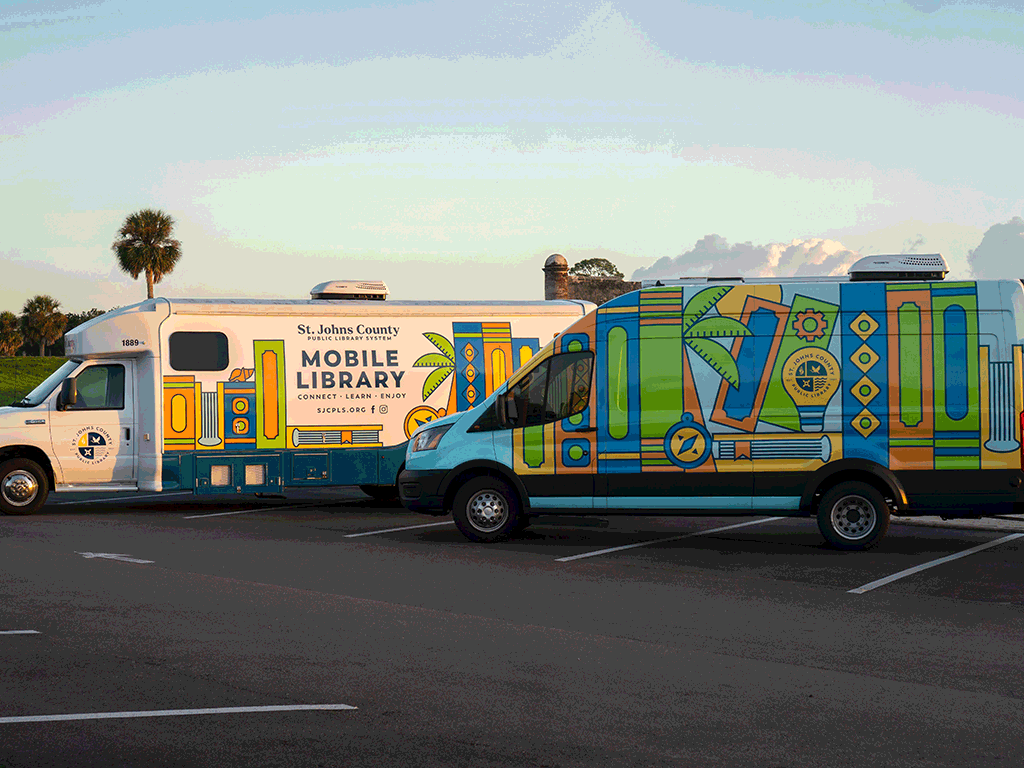
St. Johns County is using mapping technology to fill gaps in library access across a fast-growing county where new subdivisions often outpace permanent facilities. An award-winning Geographic Information Systems analysis has identified seven communities where mobile library stops could serve residents too far from brick-and-mortar branches, with two new stops launching this December in the World Golf Village area.
The St. Johns County Public Library System (SJCPLS) has selected Trailmark and Murabella as new Friday Bookmobile stops, replacing the current Mill Creek Park location beginning in December. The shift comes as the county prepares to open three new library branches over the next two years, two of which will serve areas currently visited by the Bookmobile.
What's happening
St. Johns County GIS Division staff members Stacie Amolsch and Christine Kury won two awards at the 2026 Central Florida GIS Workshop in Orlando for their project "The Bookmobile: A Novel Solution. " The map earned both the 1st Place Popular Choice Award – Map Category and the Keynote Choice Award, recognizing outstanding achievements in cartographic design and innovative applications of geographic information systems.
The GIS analysis examined areas with high housing density that are underserved by existing library locations. The methodology identified communities where residents lack a library facility within a six-mile drive and where Bookmobile services could help reduce geographic gaps in access to library resources.
The analysis also factored in practical site requirements: parking options, availability of power for the vehicle, and restroom access for library staff during stops. Seven potential service areas emerged from the analysis.
The Bookmobile currently provides library services at three public stops. With three new library branches planned to open over the next two years, SJCPLS collaborated with the GIS Division to remap service areas and redirect the mobile unit to communities that will remain underserved after the permanent facilities open.
Trailmark and Murabella in the World Golf Village area will receive the new Friday stops starting in December. West Augustine and Palencia, also identified in the GIS analysis, are being considered for future public Bookmobile stops once new library branches open and Bookmobile service is no longer needed in those areas.
How this shapes library access in a fast-growing county
St. Johns County has been among Florida's fastest-growing counties for years, adding subdivisions at a pace that challenges public-service delivery. Library access is one metric of that challenge: permanent branches cost millions of dollars and take years to plan, site, fund, and build, while new master-planned communities such as Nocatee, SilverLeaf, and developments along the SR 16 and CR 210 corridors can add thousands of households in a fraction of that time.
A six-mile drive standard is significant in a county where many newer communities sit at the edge of the suburban fringe, separated from established infrastructure by highways, wetlands, or undeveloped parcels. For families without reliable transportation, retirees who limit highway driving, or parents juggling school pickups and errands, a six-mile round trip can be the difference between regular library use and none at all.
The Bookmobile offers a stopgap: a full-service library branch on wheels that can be repositioned as the county's population center shifts. By tying Bookmobile deployment to a data-driven analysis of housing density and library gaps, the county aims to allocate a limited public asset—one vehicle, a small crew, a finite number of hours per week—where it will reach the most underserved residents.
The World Golf Village area, where Trailmark and Murabella are located, exemplifies the pattern. The corridor along SR 16 has filled with residential development over the past decade, driven by St. Johns County's top-rated schools and proximity to I-95. Until permanent library capacity catches up, the Bookmobile represents the primary point of contact for many families seeking children's programming, internet access, or materials for school projects.
What Bookmobile service means for neighborhoods
For the communities selected, a Bookmobile stop functions as a weekly anchor for library access. Residents can check out books, return materials, request holds, obtain library cards, and in many cases access Wi-Fi and digital-literacy assistance during the stop.
Bookmobile stops typically occur on a fixed weekly schedule at a publicly accessible site—often a park, community center, or shopping-center parking lot. The predictability allows families to build library visits into their routine, particularly important for homeschooling families, summer-reading participants, and residents who work from home or have flexible schedules.
The decision to replace the Mill Creek Park stop with stops in Trailmark and Murabella suggests that population growth and housing patterns have shifted since the original stop was established. As new subdivisions mature and older service areas gain access to permanent branches, the Bookmobile route can be redrawn to follow the moving edge of the county's build-out.
West Augustine and Palencia, flagged for future consideration, illustrate the longer-term planning embedded in the GIS analysis. Both communities will likely see continued residential growth, but if new library branches open nearby—reducing the six-mile service gap—the Bookmobile can leapfrog to the next underserved area. This rolling redeployment model maximizes the utility of a single vehicle and crew across a sprawling county.
Why GIS matters for infrastructure planning
Geographic Information Systems technology allows planners to layer datasets—population density, road networks, existing facilities, parcel boundaries—and identify spatial patterns that would be difficult to see in spreadsheets or anecdotal reports. In this case, the GIS Division combined housing-density data with drive-time analysis (the six-mile threshold) and site-suitability criteria (parking, power, restrooms) to produce a ranked list of candidate locations.
This data-driven approach is increasingly common in local government as counties manage rapid growth and compete for limited capital dollars. Rather than selecting Bookmobile stops based on requests, complaints, or the loudest voices at public meetings, the GIS analysis provides an objective, replicable method that can be updated as new subdivisions come online and new branches open.
The same methodology can inform other infrastructure decisions: where to site new fire stations to meet response-time standards, which roads to widen based on traffic counts and development pipelines, or where to extend sewer lines to accommodate planned density. For St. Johns County, where residential growth has consistently outpaced state and regional averages, the ability to forecast service gaps and plan interventions before backlogs become crises is a core element of infrastructure strategy.
The recognition at the Central Florida GIS Workshop underscores that the bookmobile-mapping project is both practically useful and methodologically sound—a model that other growing counties facing similar library-access challenges could adapt.
What happens next
The new Friday Bookmobile stops in Trailmark and Murabella are scheduled to begin in December, replacing the Mill Creek Park location. SJCPLS will monitor usage data—patron counts, circulation, program attendance—to assess whether the new stops are reaching underserved populations as intended.
As the three planned library branches open over the next two years, the county will reevaluate Bookmobile routes. Two of the new branches will be located in areas currently served by the mobile unit, freeing up capacity to add stops in West Augustine, Palencia, or other communities identified in the GIS analysis.
SJCPLS has indicated it will continue to use public stop data and community-needs assessments to identify opportunities to expand library services. Residents interested in library programs or Bookmobile schedules can find details at sjcpls. org.
The project supports the County's Strategic Plan priorities of Organizational Excellence and Community Well-Being, tying capital planning and service delivery to measurable data rather than anecdote or assumption.
The broader growth picture
The Bookmobile mapping effort is a microcosm of the infrastructure challenges facing Northeast Florida's fastest-growing county. As St. Johns County adds thousands of new homes each year—concentrated in master-planned communities and along the SR 16, CR 210, and A1A corridors—every category of public service must stretch to keep pace: schools, roads, parks, fire stations, and libraries.
Library access may not generate the same headlines as traffic congestion or school overcrowding, but it is a quality-of-life indicator that matters to families choosing where to live and a practical necessity for students, job seekers, and residents without home internet. By using GIS analysis to identify service gaps and deploy mobile resources strategically, St. Johns County is applying the same data-driven planning discipline to library access that it uses for roads and utilities—a recognition that in a county adding rooftops faster than branches, smart allocation of a single Bookmobile can make the difference for thousands of residents waiting for the next permanent facility to open.
Sources
- St. Johns County: SJC GIS Staff Earn Two Awards for Innovative Bookmobile Mapping Project